
What is Rheologic Airlane?
Rheologic Airlane™ lets aerial vehicles fly smarter.
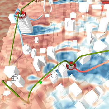
Our Software finds the fastest and safest flight path, factoring in the influence of the built environment on local wind velocities. Rheologic Airlane™ is a unique solution for routing optimal flight paths through complex wind conditions. Wind becomes an ally instead of an enemy.
With Airlane™ you can…
- Be there faster
- Fly further
- Save battery capacity
- Avoid turbulence
- Respect no-fly zones and
- Identify optimal start and landing paths
…under various wind conditions.
Airlane™ has the biggest impact on flights through urban environments and structured terrain characterized by complex wind conditions. You can double your mileage! Fly smarter! Watch our demo below!
Demo
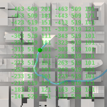
Here you can watch a roundtrip flight through San Francisco’s Financial District planned with Airlane™.
The flight begins and ends near the Ferry Building. Flight segments hit the Transamerica Building, Bank of America Tower, the Salesforce Tower, a number of offices (Charles Schwab, Uber, Microsoft, McKinsey, …) and a hotel.
Flight times for individual segments are up to 70% faster with Airlane™.
Download
Download our free demo for airlane and plan routes yourself! This fully functional beta-demo of our software is restricted to the included wind data for downtown San Franciso, providing a complex environment for testing. Use the links below to download your copy of Airlane.
Additionally you need a data package containing the simulated wind data for the demo area (San Francisco, Financial District; see links below). Future versions will allow you to run calculations in the cloud, avoiding the download for this demo version.
Tutorial
To learn how to plan your own, optimized routes for a UAV of your choice, watch the following short video series! The trial version of Airlane, that can be downloaded here is geared to professionals and the tutorial explains the interface and possibilities in a concise yet complete manner, that let’s you dive right into it (Links open in new browser tab).
Efficiency
Localized wind conditions are a big unknown in flight planning. Airlane™ calculates the interaction of wind and ground structures like terrain, buildings and trees. It then runs a “minimum-cost” algorithm to find the optimal path through the localized wind field. Airlane™ enables its users to realize the full potential of their aerial vehicles.
Airlane™ makes flights more efficient:
- Cut round-trip flight time by 50% under complex wind conditions.
- Double trips without recharging stops.
- Fly in strong wind when others are grounded.
- Plan optimal routes under any wind conditions.
All without hardware modification. Fly smarter!
Safety
Airlane™ enhances all aspects of safety: public safety, the safety of passengers and goods, and operational safety by ensuring reliable service in various weather conditions. Whether you are an urban (transport) planner, governmental organisation, UAV operator or an investor - with Airlane™ we can give your assessment the extra edge in accuracy.
- Automatically circumvent zones with high turbulence.
- Seamlessly bypass no-fly zones.
- Maintain safe distance from buildings.
- Easily define upper and lower altitude boundaries.
- Avoid gusts while approaching landing zones for a comfortable and safe flight experience.
- Identify safe flight paths for any wind conditions.
Contact
Send us a message to receive more information: airlane@rheologic.net